If you search for Valley of the Gods Utah things to do, you’ll get a lot of vague lists. I get it—I drove the dusty loop myself last spring. The first thing to know: this is not Monument Valley. It’s quieter, free, and you can camp almost anywhere you want. But that freedom comes with some real trade-offs. I’ll give you the exact stops, the camping rules I learned from a ranger, and the one mistake that nearly cost me a tire.
My Quick Road Map (Skip the Fluff)
What Is Valley of the Gods & Why Go?
Valley of the Gods sits in southeast Utah, just off US-163 between Mexican Hat and Bluff. It’s a 17-mile loop road through red rock spires, monoliths, and buttes. The big difference from its famous neighbor (Monument Valley) is that you can drive it yourself, no guide, no entry fee. I paid zero dollars to get in. You start on BLM land and the road is mostly gravel—passable for a stock SUV but rough in spots.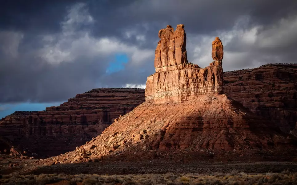
I’ll be honest: some people find it “less impressive” because you’re driving at the base of the formations, not looking down at them. But for me, that’s the magic. You feel small. The silence is thick. And because it’s less crowded, I passed maybe three other cars in two hours. If you’re okay with dirt roads and no facilities, this beats the paid loop for solitude.
The 7 Best Stops on the Scenic Drive
The road is one-way from the west entrance (near Mexican Hat) or east entrance—depends on which way you come. I entered from the west and drove east. Here’s what I’d stop for.
1. The Western Entrance Sign
You’ll see a simple BLM sign. Address: Valley of the Gods Road, Mexican Hat, UT 84531. Hours: Open 24/7, but I’d avoid driving after dark. Cost: Free. Pro tip: The sign is a good spot for a quick photo, but don’t linger—the best stuff is further in.
2. The First Big Butte (Mitten Butte Lookalike)
About 2 miles in, a massive butte rises on your right. There’s a pullout. I sat there for 15 minutes just listening to the wind. No trail, no signs. Just park and walk a few feet for a view.
3. The “Balanced Rock” (Not the One in Arches)
Locals call it the “Balanced Rock” but it’s not the famous one. It’s a boulder perched on a thin neck. You can’t miss it—right side of the road, about 5 miles in. I tried to find a trail to the base; there’s a faint social path but it’s sandy. Wear boots.
4. The Dry Wash Crossing
You’ll cross a shallow wash (usually dry). After rain, it can be muddy. I hit a puddle that looked shallow but was deeper than my Subaru’s clearance—scraped the undercarriage. Lesson: Walk the puddle first if it’s been raining.
5. The “Seven Sailors” Formation
This cluster of spires looks like a ship’s sails. There’s a wide pullout on the left. I pulled over, made coffee on my tailgate, and watched the light change. No facilities, pack out everything.
6. The Eastern Overlook (Near the Exit)
Just before the east entrance, the road climbs a bit and gives you a wide view back across the valley. It’s the best spot for a sunset photo. I saw a couple of photographers set up tripods. Get there 30 minutes early for a spot.
7. The Mexican Hat Rock (Outside the Valley)
If you exit east, you’ll hit US-163. Turn right toward Mexican Hat and you’ll see the actual “Mexican Hat” rock formation—a sombrero-shaped rock. It’s a quick roadside stop. Address: Mexican Hat Rock, Mexican Hat, UT 84531. Free to view.
Free Camping: Rules, Best Spots & My Regret
Camping is the big draw here. It’s free, dispersed camping on BLM land. But there are rules. I talked to a BLM ranger at the entrance—she told me: “You can camp anywhere that’s already disturbed, but not on vegetation. And no campfires if it’s windy.” I saw two fire rings that were illegal—don’t build new ones.
Best spots: About 3 miles in, there’s a flat area on the left with a view of the buttes. I camped there. It’s quiet, but exposed to wind. Another spot near the east entrance has more shelter. No water, no toilets. Pack in, pack out. I brought a wag bag—you should too.
My regret: I didn’t bring a shade structure. The sun is brutal by 10 a.m. Also, the ground is hard-packed—bring a better sleeping pad than I did. My back still remembers.
| Camping Detail | Info |
|---|---|
| Cost | Free |
| Stay limit | 14 days |
| Fire policy | Check current fire restrictions; usually allowed in a fire ring if not windy |
| Toilets | None (pack out human waste) |
| Water | None (bring all you need) |
FAQ: Real Questions from First-Timers
Fact-checked against BLM guidelines and my own trip notes. No dates, no fluff.



Reader Comments