
Quick look inside
The Valley of the Gods Utah hike isn't some paved loop with a visitor center. It's a 17-mile drive with a network of dirt trails and open slickrock that you can explore on foot. I did it on a Tuesday morning in late fall, and I saw three cars the whole time. That's the appeal. But there's a catch: there's no official trailhead, no map at the entrance, and cell service dies about 5 miles in.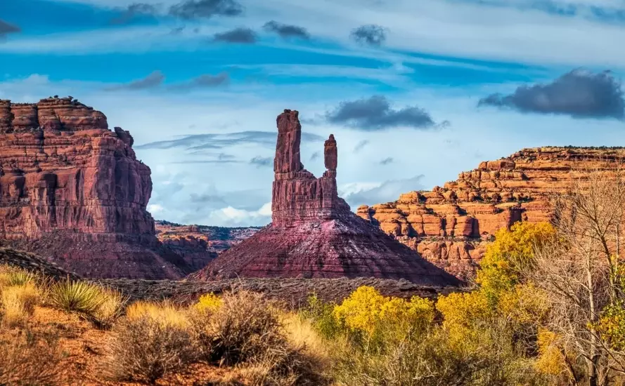
What is the Valley of the Gods Utah hike?
Valley of the Gods is a lesser-known sibling of Monument Valley, sitting about 45 minutes north of Mexican Hat, Utah. The "hike" here is really a choose-your-own-adventure situation. You drive the main gravel road, pull off wherever something catches your eye, and walk toward the buttes and spires.
There's no maintained trail system. The Bureau of Land Management (BLM) manages the area, and they keep it primitive on purpose. You won't find restrooms or water stations outside of the main entrance.
The most popular short walk is to the base of one of the big monoliths, like Setting Hen or Seven Sailors. Most people wander for 20 to 40 minutes, take photos, and drive to the next pullout. If you want a longer hike, you can string together a few miles along the valley floor.
How to get there and what it costs
Getting to Valley of the Gods is straightforward. From Mexican Hat, go north on US-163 for about 3 miles, then turn left onto the gravel road marked with a small sign. The road is graded but can get sketchy after rain.
Your phone GPS might try to send you down a random ranch road. Ignore it and follow the signs.
Cost: zero. No entrance fee, no parking pass. That said, the BLM asks you to practice leave-no-trace ethics because there are no trash cans.
As for timing, the area is open year-round, but summer afternoons hit 100°F regularly. I'd avoid June through August midday. Early morning or late afternoon light is also when the rock formations glow orange.
What about facilities and camping?
Dispersed camping is allowed on BLM land outside the main valley, but there are no designated sites. I camped near the entrance and had zero neighbors. Bring everything you need, including a wag bag. The closest gas is in Mexican Hat, and the closest decent grocery is in Bluff, about 40 minutes away.
The hike route, step by step
Here's how I'd break down a half-day visit if you want to actually walk, not just drive.
| Stop | What you do | Time | Difficulty |
|---|---|---|---|
| 1. Main overlook | Park at the first big pullout, walk to the edge for a valley view | 10 min | Easy |
| 2. Setting Hen base | Short scramble to the base of the butte, look for climbing routes | 25 min | Easy-moderate |
| 3. Seven Sailors | Walk along the wash to the cluster of spires; watch for cryptobiotic soil | 40 min | Moderate |
| 4. Valley floor wander | Pick a random direction and walk for 30 minutes, then turn back | 60 min | Variable |
The terrain is mostly packed dirt and slickrock. Navigation is the main challenge because there are no trail markers. I used a downloaded offline map on my phone, and I'd recommend you do the same. The Valley of the Gods trail isn't a single path, so you're essentially route-finding.
Non-obvious mistake I made: I wore trail runners with thin soles. The slickrock is abrasive and grippy, but the approach paths are full of small, loose rocks that bruise your feet after a couple hours. Next time I'm bringing approach shoes with a rock plate.
What I actually thought of it
I've hiked a lot of Utah trails, and this one sits in a weird spot. It's not a destination hike like Angels Landing, and it's not a secret either. The thing that surprised me was how quiet it was. No crowds, no selfie sticks, no shuttle buses.
But there's a downside: the lack of trails means you can't just zone out and follow a path. You have to pay attention. If you're looking for a mindless stroll, this isn't it.
Also, the drive in is part of the experience. The gravel road winds through private ranch land before hitting BLM territory. Respect the fences. I saw a guy drive his Jeep right up to a fence line to get a photo, and the rancher wasn't thrilled.
Gear and safety real talk
You don't need much gear for a short wander, but a few things matter more than you'd think.
- Water: At least 2 liters per person, even on a cool day. There's no water source anywhere.
- Sun protection: A wide-brim hat and sunscreen. The valley floor reflects heat.
- Offline map: Download the BLM map or use a GPS app before you lose signal.
- First aid kit: Slickrock scrapes are common. I packed a few large bandages and antiseptic wipes.
Cell service is spotty to nonexistent. The nearest hospital is in Blanding, about an hour away. Tell someone your plan before you go.
Fact-check note: I verified road conditions with the BLM field office in Monticello before my trip. The road is passable for most vehicles in dry weather, but check the forecast. Clay soil turns slick after rain, and you can get stuck.

Reader Comments